Section 1
What Land Navigation Really Means (Terminology & Mindset)
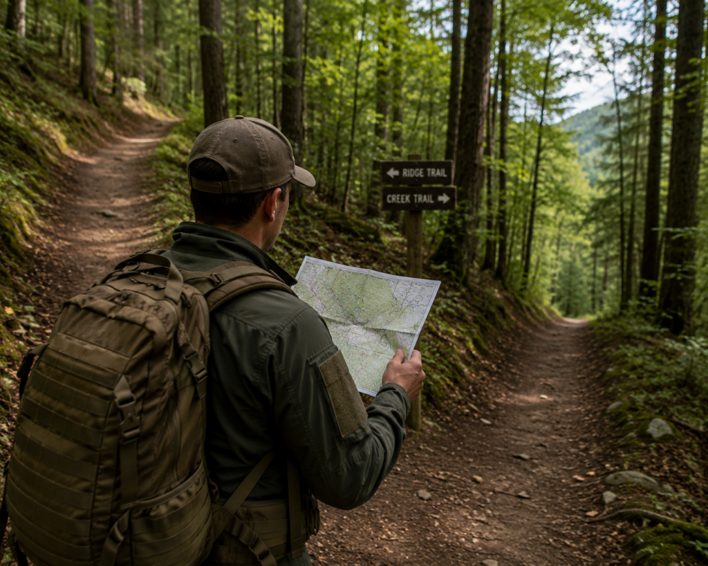
Land navigation is the disciplined skill of determining your location, planning movement, and traveling across terrain using maps, compasses, terrain features, and—only as a secondary aid—GPS. In military doctrine, land navigation is not treated as a convenience or an optional outdoor skill. It is a foundational capability that allows individuals and teams to move, coordinate, and operate when conditions are uncertain and technology cannot be trusted.
This is why land navigation is taught to every soldier, regardless of trade or specialty. Infantry, engineers, medics, and support personnel are all expected to orient themselves and move deliberately through unfamiliar terrain. The military does not assume that batteries will last, signals will remain available, or that the environment will be forgiving. Training is built around the assumption that tools fail—and that people must still function when they do.
For civilians, especially bushcrafters, hikers, and those interested in off-grid living, this mindset is directly applicable. The wilderness does not care whether you are military-trained or self-taught. Terrain behaves the same way, weather affects everyone equally, and getting lost carries real consequences. What the military treats as a professional necessity translates cleanly into civilian self-reliance.
Redundancy: The Core Principle of Land Navigation
At the heart of military land navigation is redundancy. No single navigation method is trusted on its own. Instead, navigators rely on multiple systems that support and verify one another.
In practice, this means understanding how four core elements work together:
- The map, which provides the overall plan, scale, and understanding of the terrain before movement begins.
- The compass, which gives precise directional control when landmarks are unclear or visibility is limited.
- The terrain itself, which acts as a constant reality check, confirming or contradicting what the map suggests.
- GPS, which is used as a confirmation tool rather than a primary source of truth.
If one element fails, the others prevent total loss of situational awareness. This approach contrasts sharply with modern civilian navigation habits, where digital devices often become a single point of failure.
Navigation Is Decision-Making Under Imperfect Information
Land navigation is not about having perfect information at all times. It is about making sound decisions when information is incomplete.
A navigator rarely knows their exact position with absolute certainty. Instead, they continuously estimate, confirm, and adjust. Small errors are expected, but they are identified early and corrected before they compound into serious problems. This is why military training emphasizes calm reassessment rather than panic, and deliberate movement rather than reactive wandering.
In practical terms, land navigation teaches you to:
- Anticipate terrain before reaching it
- Recognize when reality does not match expectation
- Adjust plans without losing confidence or direction
These habits matter just as much in civilian wilderness travel as they do in military operations.
Why This Skill Still Matters Today
Technology has made navigation easier, but it has not made it safer. When people become disoriented today, it is often because awareness was outsourced to a device. When that device fails, confidence collapses.
Land navigation builds confidence differently. It is rooted in understanding terrain, recognizing patterns, and knowing how to recover when uncertainty arises. It encourages awareness over speed and competence over convenience.
For bushcraft and off-grid living, land navigation is not nostalgia. It is preparedness.
Section 1 Takeaway
Land navigation is not about pointing north or memorizing tools. It is about maintaining control when certainty is unavailable. Maps, compasses, terrain awareness, and GPS are all supporting elements, but the real skill lies in judgment, redundancy, and continuous self-correction.
Everything that follows in this guide builds on this mindset.
Section 2
The North Problem: True North, Grid North, and Magnetic North
One of the first realities of land navigation is that north is not a single, fixed concept. Maps, compasses, and the Earth itself all reference “north” differently. If you do not understand this distinction, even perfect compass work can slowly pull you off course without you realizing why.
This issue—often called the north problem—is subtle, technical, and responsible for more navigation errors than most beginners expect.
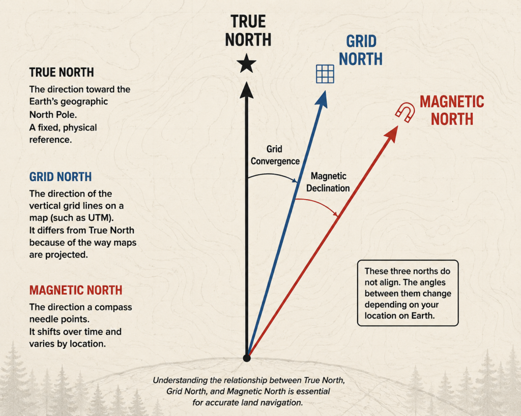
True North: The Geographic Reference
True North is the direction toward the Earth’s geographic North Pole. It is a fixed, physical location where all lines of longitude converge. True North is what you see on a globe and what satellite-based systems ultimately reference.
In practical land navigation, True North matters conceptually more than operationally. It serves as the baseline from which other systems are derived, but you will rarely navigate directly using True North in the field. Instead, it exists as the “real-world” reference behind maps and coordinate systems.
Grid North: The Map’s North
Topographic maps do not use True North directly. Instead, they use Grid North, which aligns with the vertical grid lines printed on the map. These grid lines simplify measurement, plotting coordinates, and estimating distance, but they introduce a slight deviation from True North due to map projection.
This deviation is small, but it is real—and over distance, small errors accumulate. For military and serious civilian navigation, Grid North becomes the functional north when working directly from a map.
Magnetic North: What Your Compass Actually Follows
A compass does not point to True North or Grid North. It points to Magnetic North, which is the direction of the Earth’s magnetic field. Magnetic North is not fixed; it drifts over time and varies by location.
This is where problems arise. Your map is aligned to Grid North. Your compass points to Magnetic North. If you do not correct for the difference between the two, your bearing will be slightly off. That error may seem insignificant at first, but over long distances or in poor visibility, it can place you hundreds of meters from where you expect to be.
Declination: The Correction That Aligns Everything
The angle between Grid North and Magnetic North is called magnetic declination. Declination varies by geographic location and changes slowly over time. Topographic maps display this information in the map legend, usually as a small diagram showing the relationship between True, Grid, and Magnetic North.
Declination is not an advanced concept reserved for experts. It is a basic correction that ensures your map and compass are speaking the same language.
When a navigator adjusts for declination, they are not “fixing” the compass or the map. They are aligning two different reference systems so that direction on paper matches direction on the ground.
Why This Matters in Real Navigation
Without accounting for declination, navigation errors compound quietly. A bearing that is only a few degrees off may go unnoticed at first. Over time and distance, however, that error grows until landmarks fail to appear where expected, confidence erodes, and disorientation sets in.
Military training emphasizes understanding this early because it builds trust in the process. When your bearings line up with terrain and expectations match reality, navigation becomes calm and deliberate rather than stressful.
For bushcrafters and hikers, this knowledge is what separates casual navigation from controlled movement. It explains why two people following the “same direction” can end up in different places—and how to prevent that from happening.
Section 2 Takeaway
North is not singular. Maps, compasses, and the Earth each define it differently. Declination is the key that aligns these systems and prevents small errors from becoming serious problems. Before learning how to take bearings or move across terrain, a navigator must understand what their tools are actually pointing to.
Everything that follows—bearing work, compass use, and terrain association—depends on this correction being understood.
Section 3
Topographic Maps: Reading the Ground Before You Step On It

Topographic maps are the foundation of land navigation. They do not simply show where things are; they show how the land behaves. Before a navigator takes a single step, the map is used to anticipate effort, obstacles, exposure, and route options. In military training, this skill is emphasized because it allows movement to be planned deliberately rather than reactively.
A topographic map represents the three-dimensional shape of the land on a two-dimensional surface. The key to reading that shape is understanding contour lines. Each contour line connects points of equal elevation. When contour lines are close together, the terrain is steep. When they are spaced farther apart, the slope is gentle. This spacing tells you, at a glance, where movement will be slow, exhausting, or risky—and where it will be efficient.
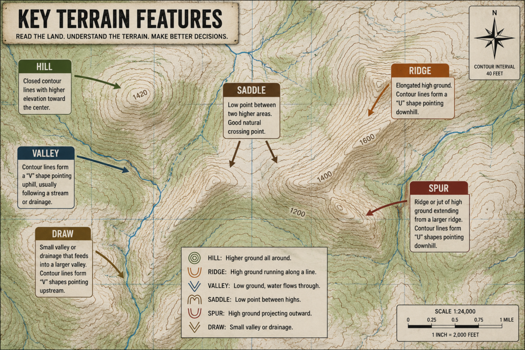
Experienced navigators do not read contour lines individually. They read patterns. Those patterns form recognizable terrain features that exist everywhere, regardless of country or map style. These features are universal, which is why military training relies on them so heavily.
Hills are shown as closed, circular contour lines, with elevation increasing toward the center. Valleys appear where contour lines form a “V” shape pointing uphill, usually following a drainage or stream. Ridges are the opposite: elongated high ground where the contour lines form a “U” or rounded shape pointing downhill. Saddles appear as low points between two higher areas, often used as natural crossing points. Spurs and draws branch off ridges and valleys respectively, shaping how movement naturally flows across the land.
Understanding these features allows a navigator to visualize the terrain before encountering it. This mental preview is critical. It lets you decide whether to stay high on a ridge for visibility, drop into a valley for concealment, or contour around a slope to conserve energy. In military navigation, this decision-making happens before movement begins, not halfway through when fatigue sets in.
Topographic maps also communicate scale and distance. Scale tells you how much ground a given measurement on the map represents in the real world. This matters because distance on flat ground is very different from distance across broken terrain. A short route across steep slopes may take far longer than a longer route that follows natural contours. Military navigation favors routes that balance distance, effort, and predictability rather than chasing the shortest line on paper.
Another critical habit taught early is map orientation. A map is not meant to be read in isolation. It is meant to be aligned with the terrain around you. By orienting the map to match the ground—usually with the help of a compass—the features on paper begin to match what you see. Hills, valleys, and ridgelines stop being symbols and start becoming recognizable landmarks. This is the moment when navigation becomes intuitive rather than abstract.
Understanding these features allows a navigator to visualize the terrain before encountering it. This mental preview is critical. It lets you decide whether to stay high on a ridge for visibility, drop into a valley for concealment, or contour around a slope to conserve energy. In military navigation, this decision-making happens before movement begins, not halfway through when fatigue sets in.
Topographic maps also communicate scale and distance. Scale tells you how much ground a given measurement on the map represents in the real world. This matters because distance on flat ground is very different from distance across broken terrain. A short route across steep slopes may take far longer than a longer route that follows natural contours. Military navigation favors routes that balance distance, effort, and predictability rather than chasing the shortest line on paper.
For civilians, this is often where navigation skills begin to separate. Many people rely on trails, signs, or digital routes and never fully learn to read terrain. When those aids disappear, confusion follows. Military land navigation avoids this by teaching terrain literacy first. The map becomes a predictive tool, not a reference checked only after something feels wrong.
The purpose of learning topographic maps is not memorization. It is pattern recognition. Once these patterns are internalized, a navigator can glance at a map and understand how movement will feel before it happens—where legs will burn, where sightlines open up, and where mistakes are likely.
Section 3 Takeaway
A topographic map is a conversation with the land before you ever step onto it. Contour lines describe shape, terrain features describe behavior, and scale describes effort. When you learn to read these elements together, navigation stops being guesswork and becomes informed decision-making.
With the ground now understood on paper, the next step is learning how to express precise location on that paper.
Section 4
Military Grid Systems (MGRS): Precision Location Without Guesswork
Once a navigator understands terrain, the next requirement is precision. Knowing the shape of the land is not enough; you must also be able to describe exactly where something is—clearly, repeatably, and without interpretation. This is where military grid systems come in.
In military land navigation, location is communicated using the Military Grid Reference System (MGRS). This system is standardized across NATO forces because it removes ambiguity. When someone gives a grid reference, every trained person understands the same location, to the same level of accuracy.
Unlike latitude and longitude, which are precise but slow to use in the field, MGRS is designed for speed, clarity, and practicality under stress.
Why the Military Uses Grids Instead of Latitude and Longitude
Latitude and longitude describe location using degrees, minutes, and seconds across a curved Earth. While accurate, they are cumbersome to plot quickly and difficult to visualize on a paper map.
MGRS solves this by overlaying a rectangular grid directly onto a topographic map. Each grid square represents a fixed area of ground, making distance estimation and location plotting fast and intuitive. This allows navigators to move seamlessly between planning, movement, and communication.
For bushcrafters and wilderness travelers, the advantage is the same: grids let you think in real distances, not abstract coordinates.
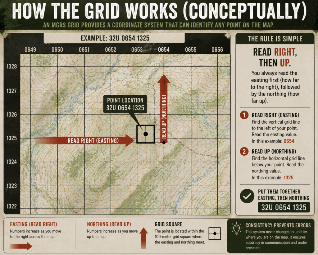
How the Grid Works (Conceptually)
An MGRS grid divides the map into squares using vertical and horizontal lines. These lines form a coordinate system that allows any point on the map to be identified by numbers alone.
The rule is simple and never changes:
Read right, then up.
You always read the easting first (how far to the right), followed by the northing (how far up). This consistency prevents confusion and errors, especially when communicating locations verbally or under time pressure.
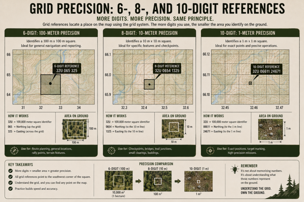
Grid Precision: 6-, 8-, and 10-Digit References
Grid references can be expressed with different levels of precision, depending on how accurately you need to identify a location.
A 6-digit grid reference identifies a 100-by-100 meter square. This is sufficient for general navigation and is commonly used during basic training. An 8-digit grid reference narrows the location down to a 10-by-10 meter area, useful for identifying specific features or checkpoints. A 10-digit grid reference pinpoints a location within a single square meter, providing near-exact positioning.
What matters is not memorizing numbers, but understanding what those numbers represent on the ground. Increased digits mean increased precision, not increased complexity.
The Role of the Protractor
To extract accurate grid references, military navigators use a map protractor. This tool aligns with the map’s grid and allows precise measurement within each square. While it may look technical at first, it is simply a way to divide space consistently.
Learning to use a protractor reinforces a key habit: accuracy before movement. Rather than guessing or eyeballing locations, military navigation favors deliberate measurement to prevent compounding errors later.
For civilian navigation, this habit alone dramatically improves confidence and reliability.
Why Precision Matters More Than You Think
Navigation errors are rarely dramatic at first. A slight misreading of a grid square might seem insignificant, but over distance, that error grows. Landmarks fail to appear, terrain no longer matches expectations, and uncertainty increases.
Military training emphasizes precision early because it builds trust in the system. When your grid references align with the terrain and your movement matches the plan, navigation becomes predictable rather than stressful.
This same principle applies to bushcraft and off-grid travel. The more accurately you understand your starting point, the less correction you need later.
Section 4 Takeaway
The Military Grid Reference System turns maps into precise communication tools. It replaces vague descriptions with measurable reality and allows navigators to describe, share, and relocate positions with confidence. Precision is not about complexity—it is about clarity.
With terrain understood and location precisely defined, the next step is learning how to move accurately between points.
Section 5
The Compass: Bearings, Azimuths, and Back Azimuths
Once terrain is understood and locations can be identified precisely on a map, the next challenge is movement. The compass is the tool that turns a plan on paper into controlled motion on the ground. In military land navigation, the compass is treated as a precision instrument, not a suggestion.
A compass does one thing extremely well: it provides reliable direction, regardless of visibility, weather, or terrain. When trails disappear and landmarks are obscured, the compass becomes the primary means of maintaining intent and preventing drift.
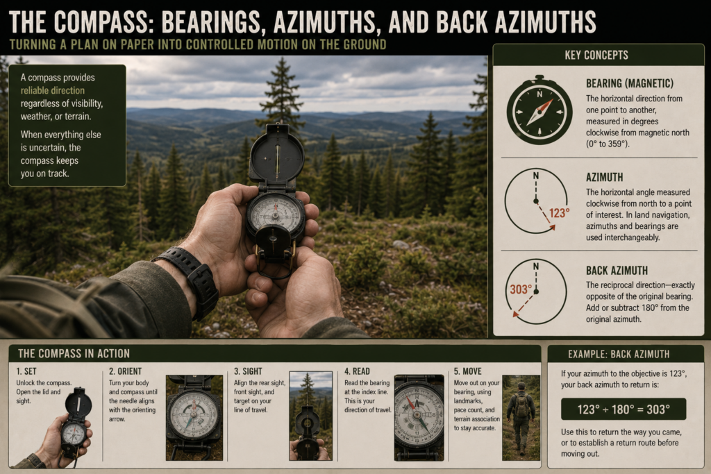
Bearings and Azimuths: Expressing Direction Precisely
In land navigation, direction is expressed numerically using bearings, also called azimuths. Instead of vague terms like “northwest” or “that way,” a bearing defines direction in degrees, measured clockwise from north, from 0° to 360°.
This precision matters. A bearing removes interpretation. Two people using the same bearing will move in the same direction, even if they cannot see each other or communicate further.
Military training emphasizes internalizing this system early because it creates consistency. Once direction is numeric, navigation becomes measurable and repeatable rather than subjective.
Taking a Bearing From the Map
Before movement begins, a navigator determines the direction of travel directly from the map. This involves aligning the compass with the map’s grid, accounting for declination, and reading the required azimuth between two points.
The key habit here is intentionality. Direction is chosen deliberately, not improvised. By setting a bearing before stepping off, the navigator knows what success looks like and can immediately detect deviation.
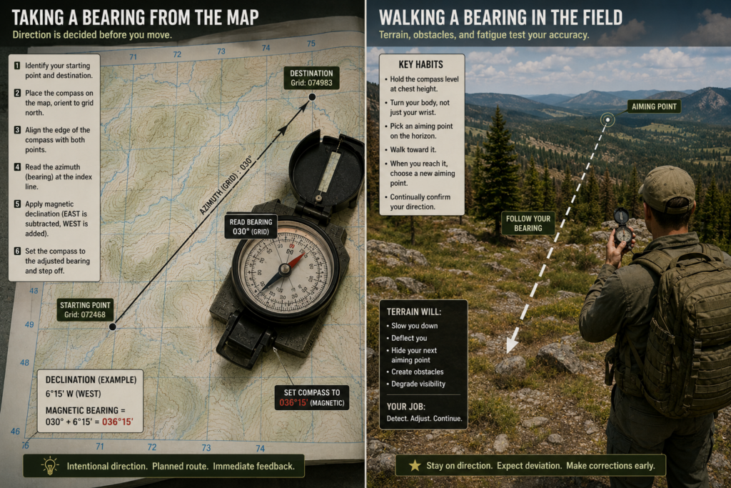
Walking a Bearing in the Field
Walking a bearing is deceptively difficult. Terrain, vegetation, fatigue, and human bias all work against straight-line movement. Most people unconsciously veer left or right without realizing it.
Military training addresses this by teaching navigators to use intermediate aiming points. Rather than staring at the compass constantly, a navigator selects a visible feature—such as a tree, rock, or terrain break—that lies along the bearing, moves to it, then repeats the process. This keeps movement efficient and reduces mental strain.
The goal is not to move fast. The goal is to move correctly.
Back Azimuths: Knowing Where You Came From
A back azimuth is the reverse of your original bearing. It allows you to determine the direction back to your starting point if needed. Calculating a back azimuth is straightforward: if your bearing is less than 180°, add 180°. If it is greater than 180°, subtract 180°.
This skill is taught early because it reinforces orientation. A navigator who always knows where they came from is far less likely to become disoriented. In poor conditions or unfamiliar terrain, the ability to reverse course confidently can prevent small mistakes from becoming emergencies.
Why the Compass Still Matters
Modern navigation often treats the compass as a backup, if it is carried at all. Military land navigation treats it as a core tool because it does not depend on batteries, signals, or software. It works the same way every time, under every condition.
More importantly, the compass trains discipline. It forces the navigator to commit to a direction, verify it, and maintain it over time. This discipline carries over into other navigation skills, reinforcing careful planning and continuous self-checking.
Section 5 Takeaway
The compass transforms maps and grid references into deliberate movement. Bearings remove ambiguity, intermediate aiming points prevent drift, and back azimuths provide security. Used correctly, the compass does not just point north—it maintains control when visibility, confidence, or conditions begin to fade.
With direction mastered, the next step is learning how to measure progress and know when you have arrived.
Section 6
Pace Count & Distance Estimation: Knowing How Far You’ve Gone
Direction alone is not enough to navigate accurately. A navigator must also know how far they have traveled. In military land navigation, this is handled through pace count and distance estimation—a set of simple but disciplined techniques that allow movement to be measured without relying on signs, trails, or electronic tracking.
This skill exists because terrain lies. What looks close on a map can feel endless on the ground, and what feels like a long walk may not be far at all. Pace count restores objectivity.
What a Pace Count Really Is
A pace count is the number of steps it takes you to cover a known distance, usually 100 meters. Once established, it becomes a personal measuring tool that travels with you anywhere.
Rather than guessing distance or relying on intuition, the navigator uses their own body as a calibrated instrument. This is why military training insists that every individual establish their own pace count. No two people walk the same way, especially under load.
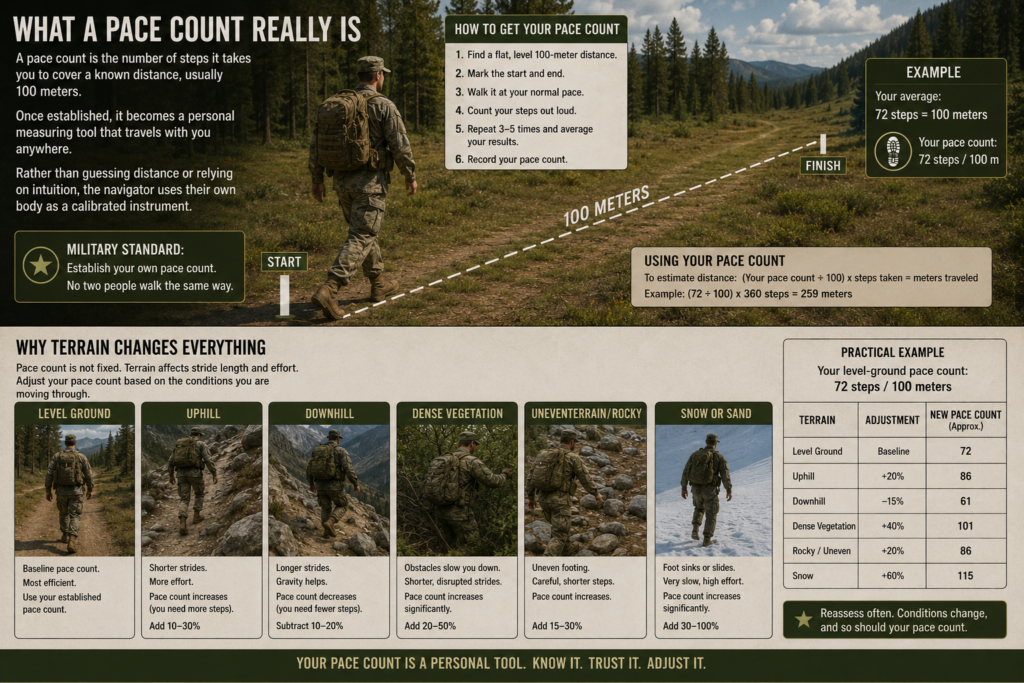
Why Terrain Changes Everything
A critical lesson taught early is that pace count is not fixed. Terrain affects stride length and effort. Moving uphill, downhill, through dense vegetation, or across uneven ground will all change how many steps it takes to cover the same distance.
Military training accounts for this by teaching navigators to understand pace count as a baseline, not an absolute. Over time, experienced navigators instinctively adjust their expectations based on slope, fatigue, and conditions.
This awareness prevents a common mistake among beginners: assuming they have gone farther—or not far enough—than they actually have.
Measuring Distance Without Markers
In practice, distance estimation works hand in hand with bearings. Once a bearing is set, the navigator begins counting paces while moving along that direction. Every predetermined number of steps—often 100 meters—the count is recorded mentally or with a physical aid.
One commonly used tool is ranger beads, which slide along a cord to track distance incrementally. The tool itself is simple, but the habit it reinforces is powerful: distance is always being measured, even when nothing on the ground appears to change.
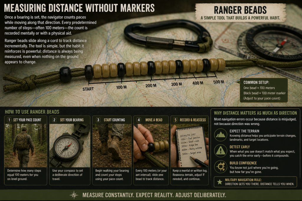
Why Distance Matters as Much as Direction
Most navigation errors occur not because direction was wrong, but because distance was misjudged. A navigator reaches the correct bearing, walks confidently, and then overshoots the objective without realizing it.
By tracking distance deliberately, the navigator knows when to expect terrain changes, landmarks, or target locations. When expectations do not match reality, the discrepancy is detected early, allowing for correction rather than confusion.
Military navigation treats this as non-negotiable. Confidence comes from knowing not just where you are headed, but how far you have progressed.
Applying Pace Count to Civilian Navigation
For bushcrafters and off-grid travelers, pace count is often overlooked because trails and GPS make distance feel abstract. But when trails fade, snow covers landmarks, or visibility drops, pace count becomes invaluable.
It allows you to:
- Know when you should have reached a feature
- Confirm position when terrain is ambiguous
- Prevent wandering past critical waypoints
- Move deliberately even in low-visibility conditions
This transforms movement from hopeful exploration into controlled travel.
Section 6 Takeaway
Pace count and distance estimation turn movement into a measurable process. Direction tells you where to go, but distance tells you when to stop, reassess, or adjust. Together, they prevent overshoot, reduce uncertainty, and maintain confidence when the environment offers few clues.
With direction and distance under control, the next skill shifts from tools to intuition.
Section 7
Terrain Association: Navigating Without Constant Compass Checks
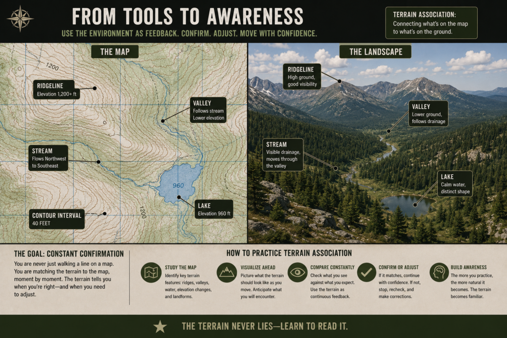
Terrain association is where land navigation stops feeling mechanical and starts becoming intuitive. Instead of constantly checking a compass or counting steps, the navigator learns to match the map to the ground in real time. This skill is emphasized heavily in military training because it allows faster, quieter, and more confident movement across complex terrain.
At its core, terrain association is the practice of continuously asking a simple question: Does the ground around me match what the map says should be here? When the answer is yes, confidence increases. When the answer is no, correction happens early—before confusion sets in.
From Tools to Awareness
Earlier navigation skills rely heavily on instruments. Bearings provide direction, pace count provides distance, and grid references provide location. Terrain association ties all of these together by using the environment itself as feedback.
Instead of treating the map as something to check only when lost, experienced navigators treat it as a live reference. Ridgelines, valleys, water features, and elevation changes are constantly compared to the map. The terrain becomes a series of confirmations rather than surprises.
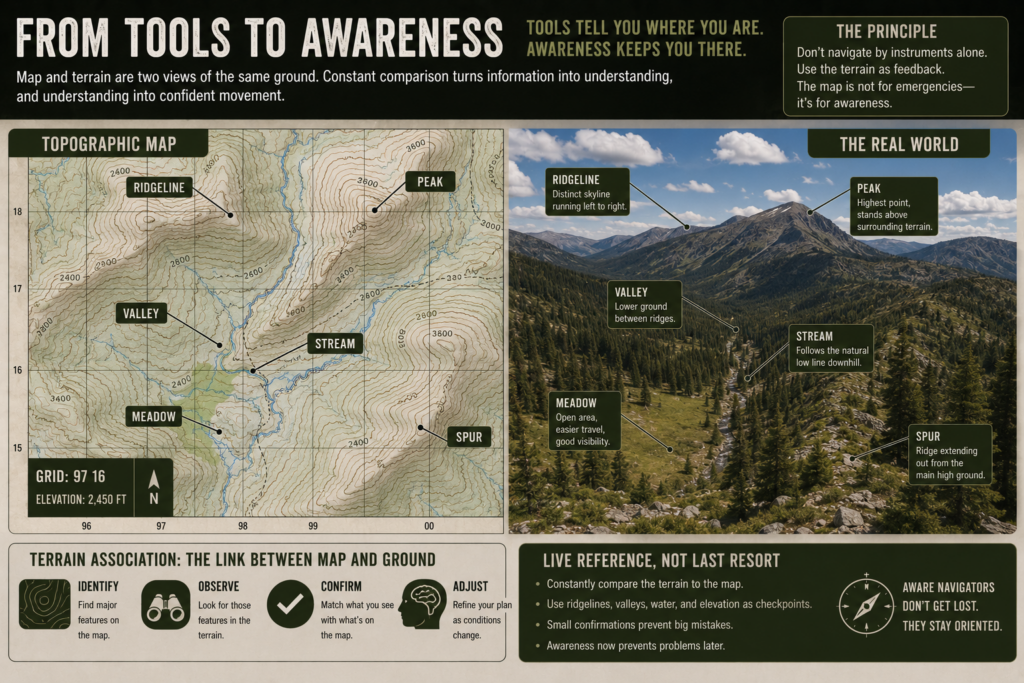
Handrails: Letting the Land Guide You
A handrail is a linear terrain feature that naturally guides movement. Rivers, ridgelines, roads, fence lines, and valleys all function as handrails. When used correctly, they reduce the need for constant compass correction and make navigation more forgiving.
Military navigation often favors routes that follow handrails because they are reliable, easy to identify, and difficult to drift away from unintentionally. For civilians, handrails are equally valuable, especially in dense forest or rolling terrain where visibility is limited.
Catching Features: Knowing When to Stop
A catching feature is a prominent terrain element that tells you when you have gone too far. Examples include a major road, river, steep ridgeline, or large clearing beyond your intended destination.
By planning movement with catching features in mind, a navigator creates a built-in safety net. If the objective is missed, the catching feature signals it clearly, preventing uncontrolled wandering.
This habit reflects military emphasis on error management rather than error avoidance.
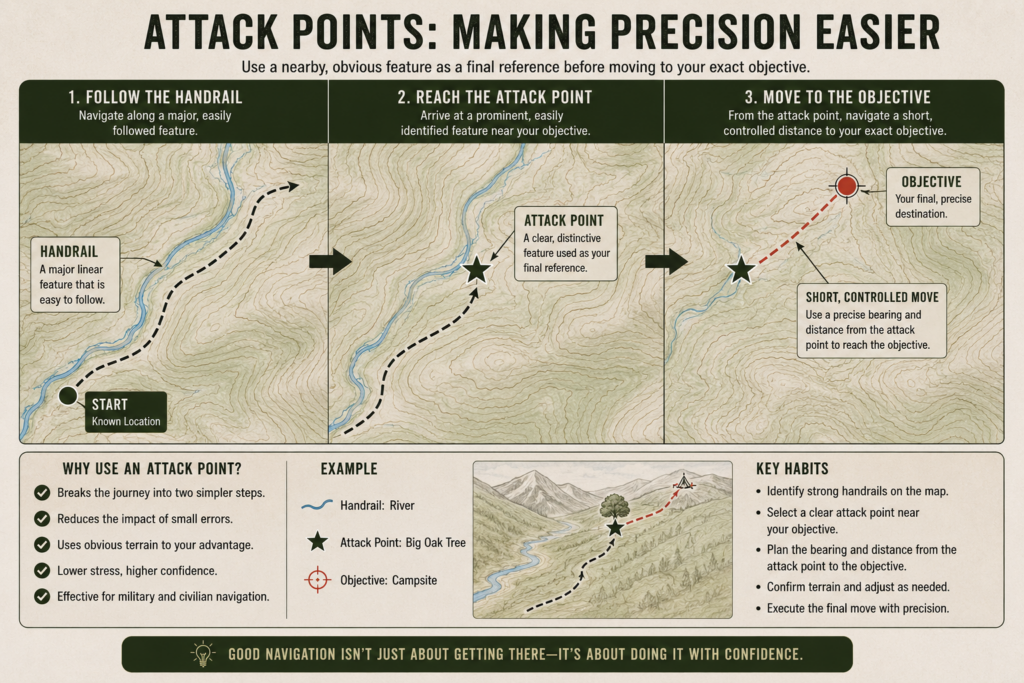
Attack Points: Making Precision Easier
An attack point is a nearby, easily identifiable feature used as a final reference before moving to a precise location. Instead of navigating directly to a small or subtle objective, the navigator first moves to a larger, unmistakable feature, then makes a short, controlled movement from there.
This technique dramatically reduces error and stress. It is one of the most effective ways to apply military navigation principles in civilian settings, particularly when locating campsites, trail junctions, or off-trail objectives.
Why Terrain Association Separates Skill Levels
Beginners rely heavily on tools. Experienced navigators rely on understanding. Terrain association allows movement to continue even when tools are briefly unavailable or impractical to use. It also enables faster decision-making because the environment itself provides confirmation.
Military forces value this skill because it supports movement under pressure. Bushcrafters and hikers benefit for the same reason: terrain association reduces mental load and increases confidence.
Section 7 Takeaway
Terrain association turns navigation into a conversation with the land. Handrails guide movement, catching features provide safety, and attack points enable precision. When the map and ground are continuously compared, navigation becomes resilient rather than fragile.
With intuition now built on solid fundamentals, the next step is understanding how modern tools fit into this system—without undermining it.
Section 8
GPS in the Military: Useful, Limited, and Always Secondary
Global Positioning System (GPS) technology is widely used in modern navigation, including the military—but it is never treated as the primary method. In military land navigation doctrine, GPS is a supporting tool, not a replacement for map, compass, or terrain awareness. This distinction is deliberate and rooted in experience.
GPS provides fast location data, but it does not provide understanding. It can tell you where you are, but not why the terrain behaves the way it does, nor how to move through it safely and efficiently.
How GPS Is Actually Used in Military Navigation
In the field, GPS is primarily used for confirmation, not discovery. Soldiers use it to verify grid coordinates, mark waypoints, and confirm that their understanding of the terrain matches reality. It is especially useful for logging positions, sharing coordinates, and double-checking navigation during planning or after movement.
What it is not used for is blind following. Military training actively discourages navigating with eyes glued to a screen. Doing so degrades situational awareness and increases the risk of terrain surprises, missed features, and poor decision-making.
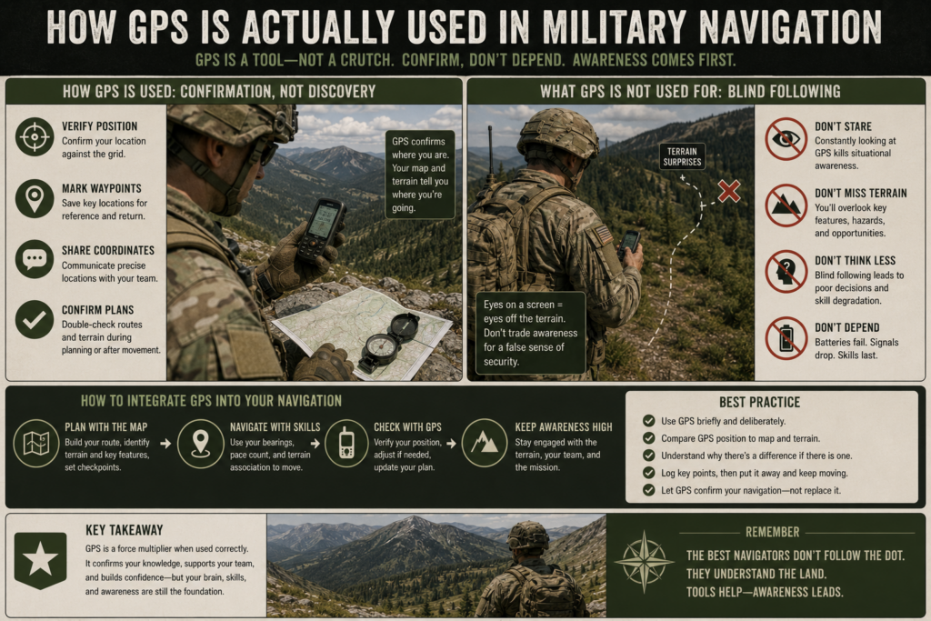
Why GPS Is Treated as Unreliable by Design
GPS systems depend on multiple layers of infrastructure: satellites, receivers, batteries, and clear signal paths. Any one of these can fail. Signals can be blocked by terrain, degraded by weather, or interrupted by technical issues. Batteries die. Screens break. Software freezes.
Military navigation assumes these failures are not hypothetical—they are expected. As a result, GPS is never trusted alone. When it works, it enhances confidence. When it fails, navigation continues uninterrupted because the foundational skills are already in place.
This mindset applies equally well to civilian wilderness travel. Remote terrain, cold temperatures, and long trips can quickly turn GPS from a solution into a liability if it is the only method relied upon.
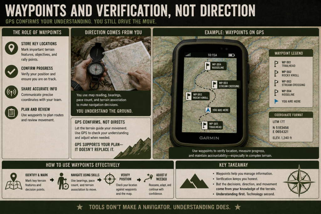
Waypoints and Verification, Not Direction
When GPS is used, it is often for waypoint management. Waypoints allow navigators to store known locations, confirm progress, and communicate positions accurately. However, movement between waypoints is still governed by map reading, bearings, and terrain association.
This separation is important. Direction comes from understanding the ground. GPS simply confirms that understanding.
The Discipline GPS Cannot Replace
GPS provides answers instantly, but it does not teach judgment. It does not encourage route planning, anticipation of obstacles, or error detection. These skills are developed only through deliberate navigation practices.
Military training values GPS precisely because it does not remove the need for thinking. It reinforces good navigation habits when used correctly and exposes weak ones when misused.
For bushcrafters and off-grid travelers, this perspective is critical. GPS should support awareness, not replace it.
Section 8 Takeaway
GPS is a powerful tool, but it is intentionally limited in military land navigation. Used correctly, it confirms location and enhances confidence. Used improperly, it creates dependency and erodes awareness. The strongest navigators treat GPS as a verifier—not a guide.
With tools, terrain, and technology now understood, the next step is learning from mistakes others commonly make.
Section 9
Common Land Navigation Mistakes Civilians Make (and How to Avoid Them)
Most navigation failures do not happen because the terrain is extreme or the tools are inadequate. They happen because of small, compounding mistakes made early and left uncorrected. Military land navigation training focuses heavily on identifying these errors precisely because they are predictable—and preventable.
Understanding these mistakes is not about criticism. It is about learning how experienced navigators think and how they protect themselves from false confidence.
Over-Reliance on GPS
The most common civilian mistake is treating GPS as the primary navigation method rather than a supporting tool. When people follow a screen instead of the terrain, they stop building a mental model of where they are. The moment the device fails, awareness collapses.
Military navigation avoids this by using GPS only to confirm location. Direction, distance, and terrain awareness come first. When GPS agrees with expectations, confidence increases. When it does not, the discrepancy is investigated instead of ignored.
Ignoring Declination
Another frequent error is neglecting magnetic declination. Many civilians know the term but dismiss it as insignificant. In reality, even a few degrees of error can move a navigator hundreds of meters off course over distance.
This mistake is dangerous because it feels subtle. Everything seems correct—until it isn’t. Military training treats declination as non-negotiable, correcting it automatically so the map and compass always align.
Poor Map Orientation
A map that is not oriented to the terrain is little more than an illustration. Civilians often read maps as static documents rather than live tools meant to be aligned with the ground.
When the map is properly oriented, terrain features begin to match what is visible, and navigation becomes intuitive. Without orientation, even accurate information feels confusing. Military navigators constantly re-orient their maps to maintain this alignment.
Failing to Confirm Position Regularly
Another common mistake is waiting too long to verify position. Many people continue moving even when uncertainty begins to grow, hoping clarity will return on its own. By the time they stop to reassess, the error has grown significantly.
Military navigation emphasizes frequent confirmation. Small checks prevent large corrections. When expectations and reality diverge, the navigator stops, reassesses, and corrects early.
Chasing Precision Instead of Control
Some beginners obsess over exact coordinates and perfect bearings while neglecting terrain cues. This creates tunnel vision. When something does not line up perfectly, confidence collapses.
Experienced navigators accept uncertainty but maintain control. They use terrain association, handrails, and catching features to stay oriented even when exact position is temporarily unclear.
Why These Mistakes Matter
What makes these errors dangerous is not their severity, but their timing. Navigation failures rarely happen all at once. They emerge gradually as confidence erodes and uncertainty builds.
Military training treats mistakes as data, not failure. The goal is not perfection, but early detection and correction. This mindset is what keeps small errors from becoming emergencies.
Section 9 Takeaway
Most people do not get lost suddenly. They drift there. Over-reliance on technology, neglected fundamentals, and delayed correction all contribute. Military land navigation avoids this by prioritizing awareness, redundancy, and frequent confirmation.
With mistakes understood and avoided, the final step is applying these skills deliberately to civilian life and bushcraft practice.
Section 10
Applying Military Land Navigation to Bushcraft & Off-Grid Living
Military land navigation is not a niche combat skill. At its core, it is a self-reliance framework—one that translates cleanly to bushcraft, wilderness travel, and off-grid living. When stripped of uniforms and doctrine, the principles remain the same: know where you are, know where you’re going, and retain control even when certainty is limited.
For bushcrafters, this shift in mindset is critical. The goal is not simply to enjoy the outdoors, but to operate competently within it.
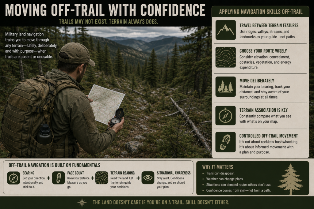
Moving Off-Trail With Confidence
Many civilian navigation habits are trail-dependent. Trails provide direction, reassurance, and implicit safety. Military land navigation assumes trails may not exist—or may not be usable—and trains movement accordingly.
Applying these principles allows a bushcrafter to:
- Travel between known terrain features rather than along marked paths
- Choose routes based on elevation, concealment, and effort
- Move deliberately through forest, hills, or mixed terrain
This does not mean reckless bushwhacking. It means controlled off-trail movement, guided by terrain association, bearings, and distance awareness.
Camp Selection and Relocation
Navigation skills directly affect where and how you establish camp. A navigator who understands terrain can select locations that balance shelter, drainage, access to water, and ease of relocation.
Using attack points and catching features makes returning to camp reliable, even in low visibility or after extended movement. This reduces stress and prevents the subtle disorientation that often occurs after multiple short excursions away from a base site.
Low-Tech Reliability in Remote Areas
Off-grid living emphasizes independence from infrastructure. Land navigation reinforces this by ensuring that orientation does not depend on power, connectivity, or software.
When weather degrades visibility, batteries drain, or electronics fail, navigation continues uninterrupted. This reliability is not dramatic, but it is deeply stabilizing. Knowing you can always orient yourself changes how confidently you move through the environment.
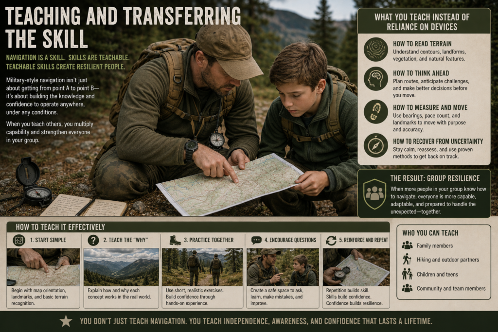
Teaching and Transferring the Skill
One of the most overlooked benefits of military-style navigation is that it is teachable and transferable. Once understood, the concepts can be passed to family members, hiking partners, or children in a structured way.
Rather than teaching reliance on devices, you teach:
- How to read terrain
- How to think ahead
- How to recover from uncertainty
This builds group resilience rather than individual dependency.
Navigation as Preparedness, Not Hobby
For many civilians, navigation is treated as an accessory skill. Military land navigation treats it as a core competency because it directly supports safety, autonomy, and calm decision-making.
In bushcraft and off-grid contexts, navigation becomes part of preparedness—not because disaster is expected, but because control is valued. You are not navigating to prove something; you are navigating so that the environment never dictates your options.
Section 10 Takeaway
Military land navigation adapts naturally to bushcraft and off-grid living because both value self-reliance, awareness, and redundancy. Trails, devices, and markers are conveniences, not requirements. When you understand terrain and maintain orientation, movement becomes deliberate rather than hopeful.
With application now clear, the remaining sections focus on supporting tools and closing perspective.
Section 11
Recommended Gear: Military Concepts, Civilian-Friendly Choices
Land navigation is a skill first and a gear problem second. The military teaches this intentionally: tools support judgment, they do not replace it. That said, the right gear reinforces good habits and reduces error, especially under fatigue or poor conditions. What follows is not a shopping list—it’s a framework for choosing equipment that supports disciplined navigation.
Compass: Simple, Durable, Trustworthy
A compass must be readable, rugged, and consistent. Military lensatic compasses are built for durability and precision, while civilian orienteering compasses prioritize speed and ease of use. Either works if the fundamentals are understood. What matters most is that the compass is reliable, easy to sight, and familiar to the user. A navigator should be able to take a bearing quickly without fumbling or second-guessing the instrument.
Maps: Current, Scaled, and Protected
A high-quality topographic map is non-negotiable. It must be appropriate for the area, use a usable scale, and be current enough that major terrain features and infrastructure still exist. Protection matters as well. Waterproof maps or simple map cases prevent damage and preserve legibility when weather turns or hands get cold. A ruined map removes your primary planning tool.
Protractor: Precision Without Guessing
A map protractor is a quiet force multiplier. It allows accurate grid extraction and bearing measurement without eyeballing. This reinforces a core navigation habit: measure first, move second. Civilian navigators often skip this tool, but its value becomes obvious the first time accuracy matters.
Pace Count Aids: Keeping Distance Honest
Distance estimation improves dramatically when supported by a physical tracking aid. Ranger beads are a common military solution, but any simple system that tracks distance reliably will work. The purpose is not tradition—it’s accountability. When distance is measured deliberately, overshoot and uncertainty decrease.
Field Notebook and Pencil: Recording Reality
Navigation improves when observations are recorded. A small waterproof notebook and pencil allow you to jot down bearings, distances, grid references, and terrain notes. This external memory reduces cognitive load and helps reconstruct decisions if reassessment is needed. Unlike digital notes, paper works in all conditions.
GPS: Treated as a Verifier
If carried, GPS should be viewed as a confirmation tool. Handheld units or phone apps can verify grids, log waypoints, and support planning—but they should never replace map awareness. Batteries fail; understanding does not. The strongest navigation setups treat GPS as optional, not essential.
Gear Philosophy: Skill Over Equipment
Military land navigation emphasizes minimalism with purpose. Carrying more tools does not make a navigator better. Carrying the right tools, understood deeply, does. Each piece of gear should reinforce awareness, precision, and redundancy—not distract from them.
Section 11 Takeaway
Good navigation gear supports discipline. A reliable compass, a readable map, a simple protractor, and basic distance tracking are enough to navigate confidently in most environments. Skill turns these tools into capability; gear alone does not.
With equipment understood, the final step is perspective—why this skill endures and how to keep it sharp.
Section 12
Final Thoughts: Why Land Navigation Still Matters
Land navigation endures because the environment has not changed, even as tools have. Terrain still rises and falls the same way it always has. Weather still obscures visibility. Fatigue still clouds judgment. What has changed is the way many people relate to these realities—often through layers of technology that promise certainty but quietly reduce awareness.
Military land navigation exists to counter that trend. It teaches a way of thinking that prioritizes understanding over convenience and control over assumption. Maps, compasses, terrain association, and GPS are not separate skills; they are parts of a single system designed to function when certainty is unavailable.
For bushcrafters, hikers, and those interested in off-grid living, this perspective is powerful. Navigation stops being something you do only when you are lost and becomes something you practice continuously. You begin to anticipate the land rather than react to it. Movement becomes deliberate, and uncertainty becomes manageable instead of threatening.
What makes land navigation valuable is not precision alone, but calm. When you understand where you are, where you came from, and what lies ahead, decisions become easier. Even when conditions degrade, you retain options. That confidence is not bravado—it is the result of disciplined awareness.
This is why land navigation remains relevant despite modern tools. Technology can assist movement, but it cannot replace judgment. Devices answer questions; skills shape decisions. When the two are combined correctly, navigation is resilient. When skills are absent, even the best tools become fragile.
The purpose of this guide was not to turn readers into experts overnight, but to provide a structured way of thinking about movement through terrain. Each section builds on the last because navigation itself is cumulative. Mastery comes from practice, reflection, and repetition—not shortcuts.
In the end, land navigation is about more than reaching a destination. It is about maintaining orientation—both physically and mentally—when the environment does not provide easy answers. That is a skill worth preserving.